Send an E-Postcard of:
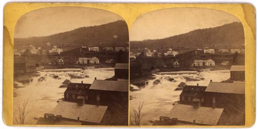
Shelburne Falls, Mass.
(c) Pocumtuck Valley Memorial Association, Deerfield MA. All rights reserved.
Contact us for information about using this image.
Shelburne Falls is a village made up of the business districts of Buckland and Shelburne. By 1869, the village of Shelburne Falls was a thriving community. Entrepreneurs on both sides of the Deerfield River harnessed its power, building mills and factories along its banks. There was a great bridge spanning the river, and railroad tracks ran along the Buckland side.
<BR>
<BR>In October of 1869 a massive storm hit the Eastern United States. The Deerfield River flooded, at times rising at a rate of six feet per hour, devastating parts of the Shelburne community. Mills, factory buildings and bridges were destroyed. Lamson & Goodnow Manufacturing Co., a cutlery along the Buckland side that employed hundreds of people, lost three vital buildings, steel, iron, coal and important machinery. This view, facing west toward Buckland, shows the river still swollen, with some of the debris from the flood just above the dam.
top of page
|
|


