icon for Home page
icon for Kid's Home page
icon for Digital Collection
icon for Activities
icon for Turns Exhibit
icon for In the Classroom
icon for Chronologies
icon for My Collection

Things To Do
Dress Up | 1st Person | African American Map | Now Read This | Magic Lens | In the Round | Tool Videos | Architecture | e-Postcards | Chronologies | Turns Activities

Send an E-Postcard of:
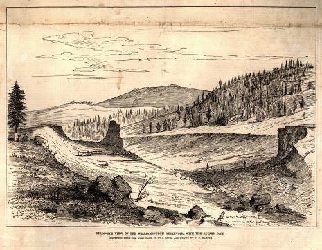
"Daily Graphic" newspaper illustration- 'Birdseye View of the Williamsburgh Reservior with the Ruined Dam'

document
(c) Pocumtuck Valley Memorial Association, Deerfield MA. All rights reserved.
Contact us for information about using this image.

Situated in the hills above Williamsburg, Massachusetts, the Williamsburg reservoir dam, nearly 600 feet long and 43 feet high, spanned pasture-covered hills. Made of a masonry core wall (a remnant of the west wall appears on the left) supported by earthen embankments, the dam blocked up a mountain stream and created a 100-acre lake. Like other New England reservoirs, it had been built by mill owners downstream to collect water that could be released in a regular flow to their factories to turn waterwheels and turbines. Reservoirs such as these made the industrial revolution possible.


top of page

Share this image with a friend.
Simply enter their e-mail address below and we'll send them this image in an e-mail greeting, along with a link to see the image on our site.

To E-Mail Address *
From E-Mail Address *
From Name
Message

* = Required


button for Side by Side Viewingbutton for Glossarybutton for Printing Helpbutton for How to Read Old Documents


Home | Online Collection | Things To Do | Turns Exhibit | Classroom | Chronologies | My Collection
About This Site | Site Index | Site Search | Feedback