icon for Home page
icon for Kid's Home page
icon for Digital Collection
icon for Activities
icon for Turns Exhibit
icon for In the Classroom
icon for Chronologies
icon for My Collection

Online Collection

document
(c) Pocumtuck Valley Memorial Association, Deerfield MA. All rights reserved.
Contact us for information about using this image.


label levels:

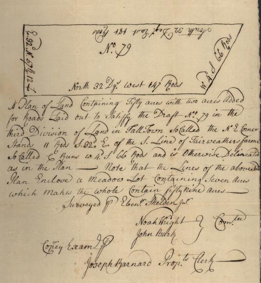
Falltown, the place where around 50 acres of land were surveyed in 1740, is now called Bernardston, Massachusetts, and is about 15 miles from Deerfield. The plot of land was granted to Joseph Barnard (1717-1785) of Deerfield, who then made a contract with the surveyor Ebenezer Sheldon, Jr. (b.1715) of Bernardston, to draw the plot, with latitude and longitude included.


top of page

Plot plan of land owned by Joseph Barnard

cartographer   Ebenezer Sheldon, Jr.
date   c. 1740
location   Bernardston, Massachusetts
height   8.75"
width   7.5"
process/materials   manuscript, paper, ink
item type   Maps/Cadastral
accession #   #L99.172


Look Closer icon My Collection icon Transcription icon Detailed info icon


ecard icon Send an e-Postcard of this object


See Also...

Advertisement in "The Boston Weekly Post-Boy" newspaper

Surveying Instrument

"Bernardston"


button for Side by Side Viewingbutton for Glossarybutton for Printing Helpbutton for How to Read Old Documents


Home | Online Collection | Things To Do | Turns Exhibit | Classroom | Chronologies | My Collection
About This Site | Site Index | Site Search | Feedback